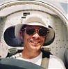
 Fly Baby Long Trip
Text
and Photos by Matt
Michael
September
2009
I’d been working on 48ML for a few years with the
goal of
having a plane that could take me on long trips. The
engine was brought back to new limits,
carb and mags overhauled… I didn’t want
to worry about anything failing and leaving me stranded, or worse. I added a canopy to a classic open cockpit
design figuring it would make long trips more practical and comfortable. I had a LOT of help in
all this and much of it was free. For
those folks I offer this account of a fun flying adventure.
In one sense, flying an old, slow, single seat
airplane
nearly half way across the country is sometimes considered a bit
extreme. On the other hand, people have
been doing it
for decades. For me, it was both
straightforward
and simple while at the same time being a very satisfying challenge
that gave
me a better appreciation for the early pioneers of long distance flying.
A stock Fly Baby, which mine was before I got it,
typically
cruises about 80 mph and has to re-fuel every couple of hours or about
every
160 miles. In an 8 hour day you might be
able to go a little over 400 miles if you can stand to sit on the less
than
plush seat in the open air wind blast for 6 flying hours.
Many have done it, and they certainly had
great stories to tell. Pete Bowers, the
designer of the plane, did many longer trips across the country in his
prototype.
While overhauling 48ML I realized that just a few
small
improvements might result in significant gains in long distance
performance. I had the prop twisted to
achieve a little more thrust in cruise flight, changed the fuel tank
from 12
gallons to 16, and added 6 more gallons of auxiliary fuel.
Now, cruising at 90 mph and able to stay up
for nearly 4 hours, I could fly over 350 miles before stopping for fuel. In an 8 hour day I might be able to go 700
miles!
So, I’d been yearning for some reason to go
somewhere since
finishing the overhaul and all the enhancements on my cute little plane. When I got word that Col,
Harold Fischer, Korean War double ace and my deceased fathers best
friend had
passed away and was going to be honored at Arlington
National Cemetery
on September 14th, an idea began to form in my mind.
My dad was a P-38 pilot in WWII and when he
died suddenly in 1967 “Hal” got leave from active duty in the Air Force
and
traveled a long way to be at the funeral.
Later, in the 80s he wrote me a letter telling me about his
friendship
with my dad. Here was an opportunity I
thought, to honor the friendship of two great pilots, to stand up in my
fathers
place, and to do it as a pilot.
I flew to the Antique Airplane Association’s fly
in at
Blakesburg in early Sept. for an overnight camp-out as a shakedown
flight. I found that the battery powered
electrical
system for lights, strobes, and fuel transfer pump worked perfectly. Everything on the new instrument panel worked
properly. The seat was a little less
comfortable than I’d realized however and the plane had a slight but
annoying
tendency to want to turn left on it’s own.
In the week prior to the funeral in DC I worked like a fiend
carving
foam to make a contour fit seat that didn’t kill my back and tweaked
the wing
wires to get 48ML to fly straight. I
also added a simple bungee cord trim system to the control stick that
would
keep the plane from diving or climbing on it’s own while I folded maps
or ate
or stretched.
As the weekend of September 12th approached I was
ready but
knew that I must have perfect weather to make the trip.
Not only would it be poor judgment to attempt
such a long flight in questionable weather, I couldn’t afford to be
delayed
getting home since my wife was scheduled to leave for Scotland
2 days after the funeral. Beyond all
odds and hopes the weather WAS perfect.
It was a perfect forecast for weeks across at least half the
continent! Sunny, light winds, hardly a
cloud in the sky, for hundreds and hundreds of miles!
Amazing.
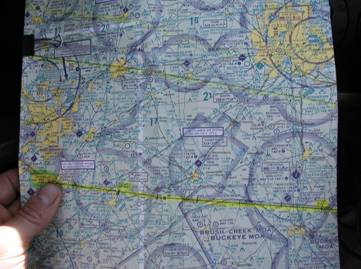
I mapped the route from Ames
to the DC area with regard to car gas fuel stops. I
can burn car gas in my plane and it’s
typically cheaper than airplane gas.
Strangely, there is a huge gap in airport car gas suppliers
across Ohio
which was right on my route. There was
one small grass airport just southeast of Muncie,
Indiana that offered it so I chose
that as
a fuel stop. If I topped off at Muscatine
Iowa on the Mississippi
river
I could just make it to Muncie. I pulled a 5 foot mirror from a bedroom door
to use as a straight edge to draw the route lines across 3
taped-together
sectional charts.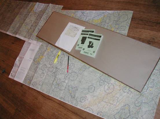
The day before I was planning to
leave, my friend Chris Uhl
in Cincinnati called
saying he’d
heard I might be flying his way. I told
him I was wondering about car gas at airports in Ohio. He said that he didn’t know of any but that
if I stopped by Cincinnati
he and
Julie would meet me and give me a place to sleep. I
quickly modified my route from Muncie
to angle south to a little airport near Cincinnati
where Chris flies gliders and J3 Cubs.
Saturday morning a Temporary Flight
Restriction was to go
into effect for the Ames
airport
starting at 10am due to the
college
football game. I had my hands full
getting myself ready and loaded and in the air before 10.
With no transponder in 48ML I would have no
way to get out of Ames
while the
TFR was in effect. As I taxied by the
terminal the secretary called me on the radio to remind me about the
TFR. I told her I had a couple more
minutes on my
clock and I scooted south away from the stadium as fast as I could.
The 134 statute miles to Muscatine
was uneventful but I was really pleased with the seat comfort and how
nicely
the trim and rigging had worked out.
48ML flew like it was on rails which gave me a good feeling
about the
potential workload ahead. I cruised at
3500 MSL or about 2500 feet above the ground in perfect weather and
landed an
hour and a half later. Re-fueling was a
drag as I managed to splash half a gallon of fuel all over the plane
and myself
when the hose surged and caught me off guard while filling the main
header
tank. Fortunately, they have a shower at
the Muscatine airport and
after I
removed and filled the aux tank I cleaned up and changed clothes. I loaded the aux tank into the baggage
compartment with all its’ tie downs and supports then packed everything
else,
including my fuel soaked clothes in a garbage bag.
I called Flight Service for a briefing on
winds aloft and TFRs along my route then, after pushing to a tie-down
and hand
propping to start, I was off towards Muncie,
316 miles away, at 12:48pm.
This was the first take-off with ALL my
baggage AND aux fuel
which put 48ML right at max gross weight.
It still leaped into the sky and climbed nicely at around 400
feet per
minute. I cruised-climbed to 7500 MSL
where I would be above the developing thermal clouds, and hoped to get
better
speed and gas mileage. I set the
throttle at 2500 rpm and the exhaust gas temp at 1300.
Airspeed was about 84mph.
The landscape below the clouds was about the same
as Iowa
but far from being dull and monotonous as it might be from a car. Multiple hues of green, mile square farm
fields interspersed with occasional small towns and tree lined rivers
in every
direction to the horizon is quite pleasing to the eye.
But, it makes navigation somewhat
challenging. It’s easy to confuse one
little town with another and convince yourself you are either on course
when
you’re not, or off course when you aren’t!
But it’s a fun game to play and it’s easy to relax knowing that
if there
is engine trouble there are a lot of good places to land.
I mainly used a sectional chart and the compass to
find the
route but I do have a simple GPS unit that gives me ground speed,
heading, and
lat./lon. I’d use it occasionally to
check my old fashioned speed, heading, and position calculations. I was tempted to go without the GPS just so I
could say I didn’t use one but since it was available I thought it
better to
have just in case I got lost. I also
have a fire extinguisher, a carbon monoxide alarm, a radio, and a
parachute all
for safety’s sake so why not the GPS?
3 hours and 48 minutes
after
leaving Muscatine I found
Reese
airport near Muncie, IN
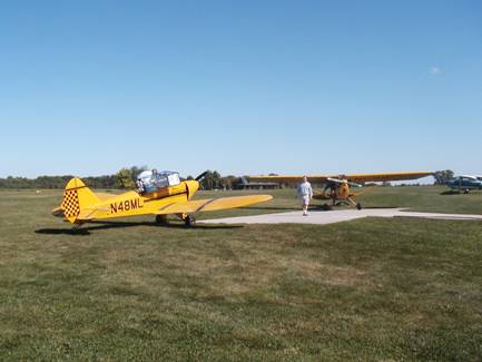
and landed at 4:30pm. There were a couple of yellow Piper Cubs
there and while fueling a small bi-plane landed and taxied up near the
pumps. When I returned from paying in
the small terminal building there were 5 or 6 friendly guys standing
around
chatting and looking over the planes.
One asked what sort of plane I was flying and another, the bi
plane
pilot, said he was going to just pass by but had to land to see what
the heck
kind of plane mine was. They’d seen Fly
Baby’s before but not with a canopy which I said was a pretty good
disguise.
It occurred to me that
here, at
this old-timey sort of airport there might be someone who was
experienced in
hand propping to start my engine. This
relieves me from having to go through a complex and time consuming
process of
tying the tail hook, chocking the wheels, going to and fro multiple
times to
turn the prop with the ignition off, then on, removing and stowing the
chocks,
and finally climbing in the cockpit with the engine already going. So, I asked if anyone might be able to hand
prop me? Every guy raised his hand, then
started laughing. Someone said, “take
your pick”.
 I took off at 5pm
and headed southeast for Stewart airport, 78 miles away just outside
the busy
Cincinnati Class B airspace. An hour
later I was flying this way and that trying to find this grass airport
in the
otherwise mostly green landscape. There
was a yellow J3 Cub in the pattern and a couple more parked near the
hangers
along with a blue and yellow Stearman. I
saw Chris and Julie waving me toward a parking place as I taxied in.
I took off at 5pm
and headed southeast for Stewart airport, 78 miles away just outside
the busy
Cincinnati Class B airspace. An hour
later I was flying this way and that trying to find this grass airport
in the
otherwise mostly green landscape. There
was a yellow J3 Cub in the pattern and a couple more parked near the
hangers
along with a blue and yellow Stearman. I
saw Chris and Julie waving me toward a parking place as I taxied in.
I was elated to be now more than half way to DC
and to have
good friends to meet me and to stay with overnight.
After securing 48ML for the night we went
straight to Deweys for some of the best pizza I’ve ever had with some
of the
best company on the planet.
Sunday
morning was pretty relaxed since I only had 317 miles
to go to the DC area. By the time we
drove back to Stewart and I went through all the fueling and loading it
was
well past 11. Chris helped a lot and
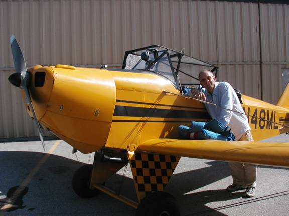
took some photos showing me shoehorning myself into the cockpit.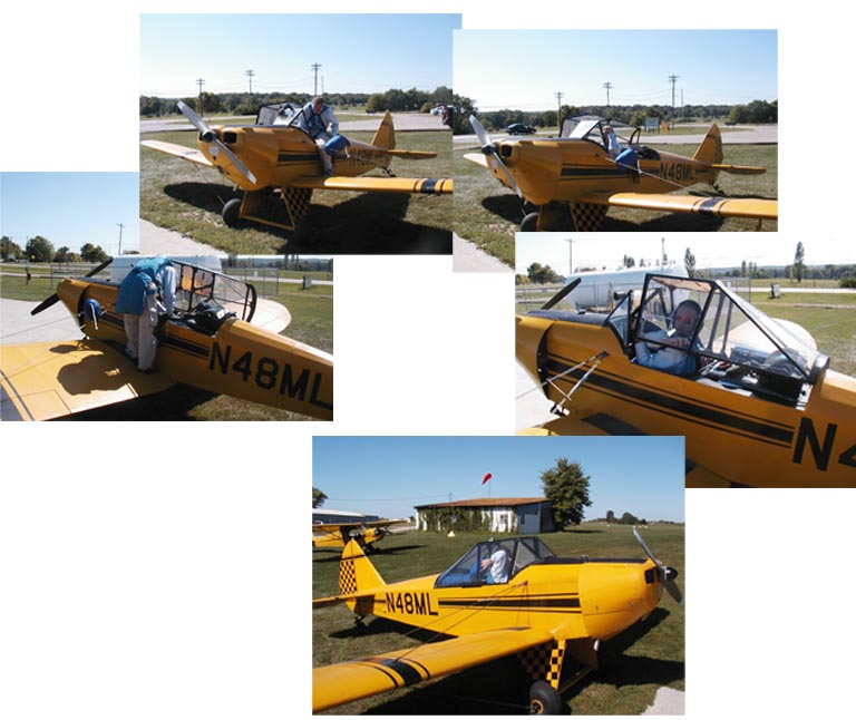
Chris hand propped me and I took off at 11:35. I
climbed
at 60mph for an average rate of 320 fpm up to 5500 MSL.
At 2500 rpm my airspeed was 80 mph. The
outside air temp was 57F and my groundspeed was about 92 mph.
 It
wasn’t long before I left the flat farm landscape of the Midwest
behind and found myself over the forested hills of West
Virginia.
It
wasn’t long before I left the flat farm landscape of the Midwest
behind and found myself over the forested hills of West
Virginia.
There weren’t a lot of places to
land down there so I kept
an extra sharp eye on my position and for any airports along the way. I think my experience as a glider pilot
helped put me at ease here. Even in the
most densely forested areas I could see little clearings and pastures
near
rivers that I was pretty sure I could put the Fly Baby down on if the
engine
quit. I’m not saying it would be easy
but at least I’d had the experience of dropping in on pastures without
an
engine before. And, if there was no
place to go but into the trees I’d use the parachute.
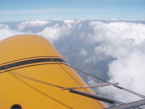
As I flew further east over the
higher terrain of the Appalachians
the little convective clouds grew taller and soon reached my altitude. I enjoyed deviating around them but
eventually climbed another couple thousand to get above them. Before long I was on the downside of the
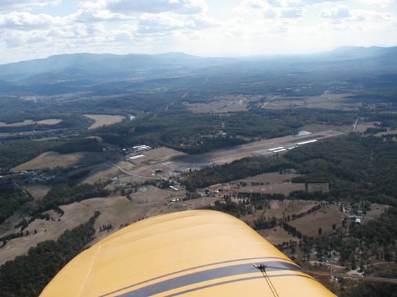
highlands and began my descent to Front Royal airport just outside the
Washington DC Security Zone. Flight
duration was 3 hours 35 minutes.
Here I was met by my glider buddy Bob Ball. Bob was a good
friend of Pete Bowers, the designer of the Fly Baby when they were
flying
gliders together near Seattle
in
the late 50s. I felt privileged to have
such support on the far side of this journey.
Bob had flown little airplanes across the country on more than
one
occasion and knew what it entailed. He
brought cans full of auto gas and helped me tie down, then drove me an
hour
east to his house so I could change my clothes.
After that, he drove me to Bolling Air Force Base in the heart
of DC
where the Fischer family was having a memorial BBQ in honor of the
Colonel.
The next morning I put on the
pinstripe suit that had
traveled rolled up on 48MLs turtle deck and went to Arlington
National Cemetery
for the service. In my pocket was a pair
of my dads Air Force sterling silver wings.
There was a band, an honor guard, and a horse drawn caisson. The day was bright and sunny with light
winds. The acres and acres of white
headstones on green hills a stark yet beautiful reminder of so many
sacrificed. There was a long walk behind
the caisson, taps, the startling report of the gun salute at graveside,
words
about an amazing flying career, time as a POW in China,
about freedom. There was no missing
plane fly-over because of the post 911 security enhancements to the DC
airspace. Apparently almost no one gets
that any more but Col. Fischer would have in another time.
It was just as well as I’m pretty sure I’d
have completely lost my composure.
It was a long and convoluted
chain of lost car keys, missed
exits, and confusion that followed a very nice luncheon on the Potomac. Now that my reason for being in DC was done I
wanted to start home immediately. My
wife was due to leave on Wednesday and I wanted to see her off. I didn’t get back to Front Royal airport till
past 3 in the afternoon, finally thanks to Bob Ball.
Once I was in his car things went like
clockwork. By this time I was no longer
fixated on getting back to Cincinnati
before nightfall but I hadn’t completely ruled it out either. 48ML has battery operated position lights and
strobes that can run for a couple hours.
I also carry a tent and sleeping bag so that I am never tempted
to push
on into unfamiliar territory in deteriorating conditions.
By the time I was fueled and
packed it was 4:45pm.
Flight Service said sunset at my destination was 7:49. I
wasn’t
going to make it to Stewart in time.
There are no runway lights there but there were several airports
close
by that do have lights as well as many along the route.
It took me 20 minutes to climb to 6000 feet
as I headed west over the rising terrain of the highlands and I
continued up to
cruising altitude of 6500. My
destination was Lebanon Warren
County airport just 6 miles
past
Stewart.
The sky was very hazy on this leg
of the trip. I wondered if all the forest
fire smoke from California
that had made the Midwest so hazy the previous
week was
now settling over the Virginias. From altitude there really wasn’t much to see
but blue above and white below. If I
looked almost straight down and behind I could see the ground but it
was tough
to pick out checkpoints unless they were large and close to my route. To the west toward the sun there was nothing
but the top edge of the haze layer marking the horizon.
There were a few small clouds to dodge over
the highlands but mostly it seemed I was hardly moving.
I kept watch for traffic and made position
reports on the radio whenever approaching an airport.
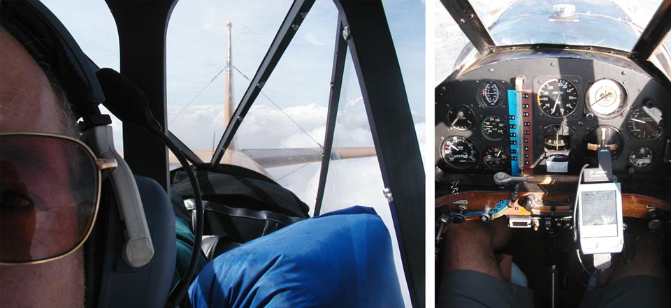
There wasn’t much to see outside so I took a
couple photos inside
One of the highly visible
checkpoints was the Ohio River where it makes a
huge bend at Parkersburg
on the border between OH and WV. Once I
was past that I decided to descend a couple thousand feet figuring the
visibility would improve and I’d be able to see the ground better. It didn’t help much at all and with the sun
getting lower in the west the visibility might have been a little worse. The air was smooth and the engine was humming
along just fine. I started to look
forward to nightfall as I knew the haze layer would vanish and the
lights of
towns and roads would make navigation easy.
I checked several weather stations to make sure fog wouldn’t be
an
issue along the route. Sometimes as the
air cools after sunset ground fog can form quickly.
No fog tonight so I kept on going into the
setting sun.
Sure enough, once the sun was down and
lights on the ground
began to appear I could see for 30 miles easily. I
diverted a little from my route to fly
closer to airports and used my radio to turn on their runway lights
BEFORE it
got completely dark. That way, if my
radio failed to do the trick I could land now while it was still light
enough.
When I saw the glint of the large lake
near Stewart airport
up ahead in the dark I knew I was right on course.
I began my descent and transferred the last
of the auxiliary fuel to the main tank.
All I had to do was fly right over the lake and I’d be heading
directly
toward Lebanon
airport. Already I could see the lighted
beacon and soon the runway lights came into view ahead.
To my left the dazzling carpet of lights from
Cincinnati sprawled across
the
horizon and to my right the lights of suburbs and Dayton
farther north. It was beautiful, and I
was really proud of my plane for taking me on such a voyage. Chris and Julie were there to meet me again
and we had a wonderful dinner and talked way past when we should have
gone to
bed.
Chris dropped me off at the airport in
the morning before he
went to work and took a parting photo with my camera.
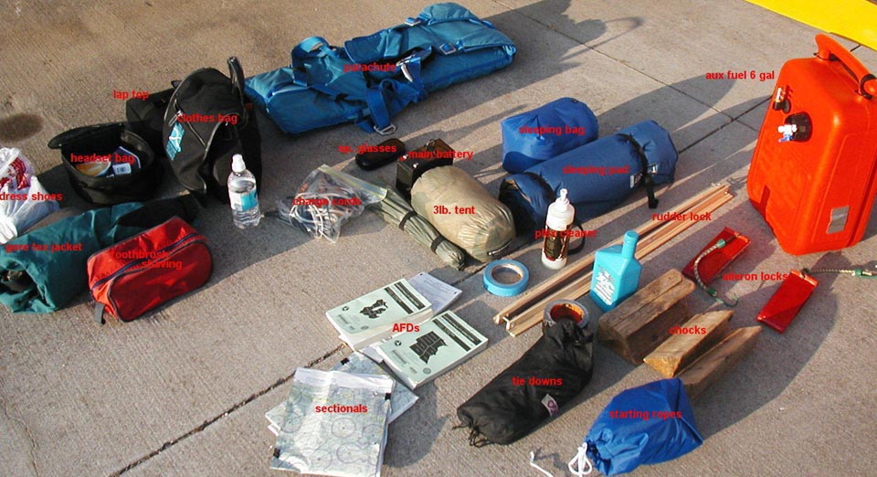
I knew I had perfect weather and plenty of time to
get home
so took the opportunity to document all my paraphernalia before packing
everything. This doesn’t include my
dress suit that was already packed.
 I took off at 9:48
and headed back the way I came, toward Reese airport near Muncie. I was still thinking of stopping there to top
off the fuel and it’s easier to navigate a familiar route.
Additionally, to fly direct toward Iowa
I’d have to cross the corner of yet
another map which would make the already fussy business of folding and
refolding these very large pieces of paper in such a cramped space even
worse. As I approached Muncie
and got an idea of my speed and fuel consumption I decided to try to
make it
all the way to Muscatine
without
stopping. I seemed to have a little bit of a tailwind which made my
groundspeed
about 104mph. I cruised along at 4500
MSL and when the mid day thermal clouds started to get in the way I
went under
them for a slightly bumpy ride. This
turned out to be the longest leg of the trip.
4 hours and 5 minutes after leaving Lebanon
I landed at Muscatine,
almost
exactly 400 statute miles.
I took off at 9:48
and headed back the way I came, toward Reese airport near Muncie. I was still thinking of stopping there to top
off the fuel and it’s easier to navigate a familiar route.
Additionally, to fly direct toward Iowa
I’d have to cross the corner of yet
another map which would make the already fussy business of folding and
refolding these very large pieces of paper in such a cramped space even
worse. As I approached Muncie
and got an idea of my speed and fuel consumption I decided to try to
make it
all the way to Muscatine
without
stopping. I seemed to have a little bit of a tailwind which made my
groundspeed
about 104mph. I cruised along at 4500
MSL and when the mid day thermal clouds started to get in the way I
went under
them for a slightly bumpy ride. This
turned out to be the longest leg of the trip.
4 hours and 5 minutes after leaving Lebanon
I landed at Muscatine,
almost
exactly 400 statute miles.
The final leg home to Ames
was completely straightforward. It’s
funny how ones perspective about distance changes after a long trip. Before my flight to DC, the idea of flying to
Wichita to see my pal Tony
seemed a
major expedition. Now I realized I could
do it in one hop and be there in about 3 hours!
No problem!
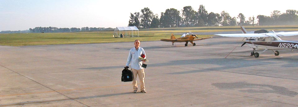
My mom had followed the progress of my
trip and the funeral
closely. She met me as I taxied in at Ames
smiling and taking photos. I handed her
my camera and asked her to take one more before I put 48ML in the
hanger.
Matt Michael
Check out Matt's other postings on how he built his canopy and baggage compartment.
 Return
to The Stories Page
Return
to The Stories Page